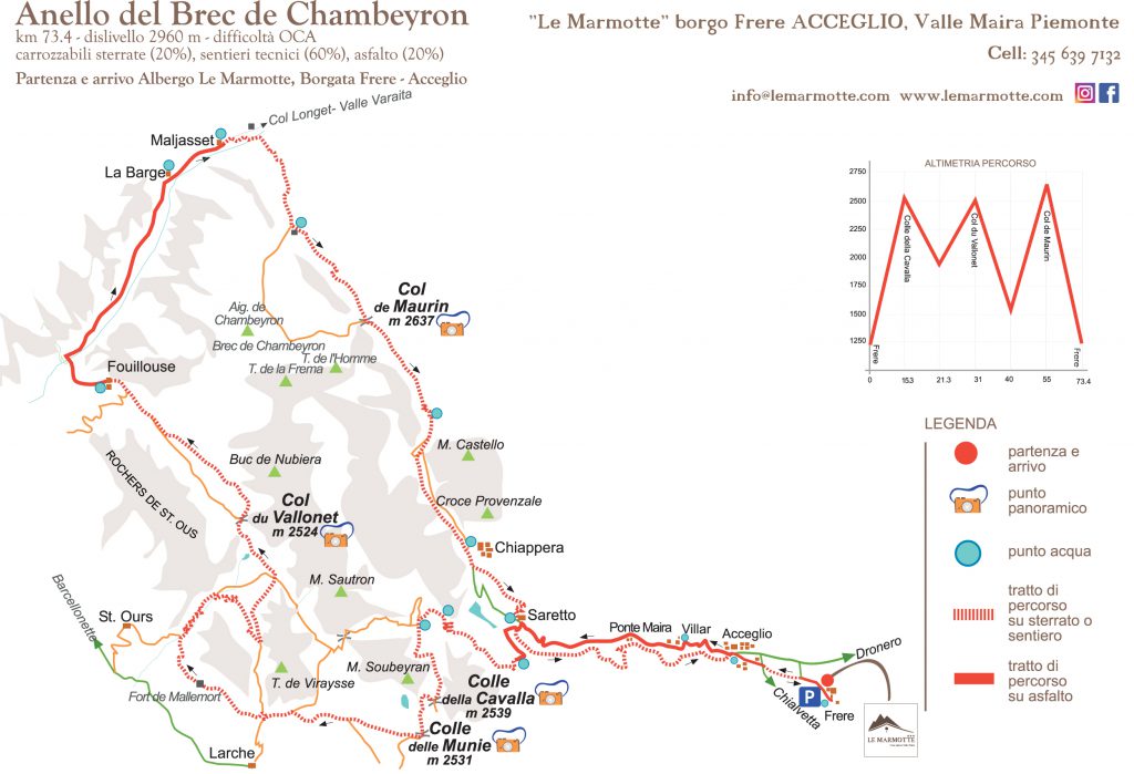
THE LOOP ROUTE OF BREC DE CHAMBEYRON
Foto


Good, after a rich breakfast you are ready to head out. No cars! You leave directly from here on your MTB.
The proposed itinerary is a serious excursion that presents a series of technical challenges and a considerable elevation gain. Attempt this route only if you are physically and technically prepared for such difficulties!
Leave the Marmotte Hotel and proceed in the direction of Acceglio along a dirt track that traces back to the right of the Maria stream, until you cross over the paved street near b.ta. Saretto. (1525 m)
Continue to climb, first on asphalt, then following the military road that leads to the Grangie Pausa. Keep the left along the path to Passo della Cavalla (2539 m).
Here, continue to the right reaching Colle delle Munie (2531 m).
Now go down on the French side keeping the right in the direction of Larche, following the Rouchouse valley between the Teté de Viraysse and the Teté Dure (yellow-red GR marks).
At an altitude of 1970 m take the branch road to the right for the Col de Mallemort and, at the next junction, follow the path (on the left) to the Plateau de Mallemort on the left.
Cross the military road that goes up to the Tete de Viraysse, follow it uphill until you reach the Lower Fort of the Viraysse (2503 m) where you turn left along the path towards the col du Vallonnet (2524 m).
Now go down towards Fouillouse and reach on asphalt, first downhill and then uphill, the borgata of Maljasset.
Here you start the last challenging climb with sections where you have to carry the bike over your shoulders, along the Vallon de Mary up to the col de Maurin (2637 m).
You have arrived at the panoramic destination! A bit of effort but it was worth it, right?
Time for photos! Snap away and share with our hashtag:
#albergolemarmotte #vallemairabikeexperience #mairavigliosa
Start now to descend on the Italian side reaching grange Collet and down to the village of Chiappera (1650 m) following either the dirt track that runs alongside the majestic Provenzale – Castello rock or the path that runs on the right bank of the Maurin river.
When you reach Chiappera, follow the yellow notches of the P.O. to reach La Crocetta and down to borgata Saretto.
The forest trail on the right bank of the Maira torrent allows you to reach the borgate Ponte Maira, Acceglio main villa and borgata Frere avoiding the asphalt.
You have returned to the Marmotte Hotel. Today’s excursion is over. Good Job!
Now you can enjoy a well deserved rest in the garden, sipping a nice cold beer!
Equipment
The routes usually start in high alpine environments and at a high altitude which are subject to rapid climatic change. You need clothing which allows you to adjust for these changes.
Before you leave, be sure to check that you have (either by wearing or carrying a pack) these three basic items:
- UNDERWEAR LAYER: The layer against the skin must allow for air circulation, and must wick moisture away from the body quickly.
- MIDDLE LAYER: The second layer must provide insulation while also allowing moisture to escape.
- OUTER LAYER: The outermost layer must provide protection from the elements such as wind and rain, while still allowing the body to breath and moisture to escape.
While some people consider helmets annoying and ugly, they without a doubt are essential.
Before leaving, be sure to adjust the helmet for total enjoyment.
They are very useful for protecting your eyes from the atmospheric elements.
It is important that they firmly enclose your face so you never need to remove your hands from the ski equipment.
The very best lenses are photochromic: designed to adapt to different kind of lights.
Using gloves is a very good habit because they ensure correct grips on equipment and the cushioning in the palms absorbs vibrations for a more pleasant run.
These basic items will limit injury in the case of a fall.
Short ones or long ones… are personal choices.
One or more of these should be filled before setting out.
Always check a map for water points along your path.
When choosing a backpack lightness and comfort are especially important. The backpack, in addition to carrying things, must also provide optimal distribution of the weight of items .
Before setting out, adjust all the straps and tension bands.
The ideal backpack for a day of MTB should have a capacity of 25-30L with a series of useful pockets to separate the following:
– clothing (wind-breaker, undershirt, long gloves, batteries, sun creams, etc.)
– food (energy bars, fruit, supplements, etc.)
– First Aid Kit (gauze, bandages, scissors, gloves, disinfectant, cotton bandage roll, thermal towel,etc..
– Accessories or emergency mechanical parts air chambers, cans, brake wire, adhesive tape, multi-purpose key, beagle levers, pliers, pump …)
–Various accessories (topographical maps, multi-function knife, GPS, head lamp, cellphone, camera, etc.)
During an excursion, it is advisable to have a working cell phone with you (even if turned off) with a fully charged battery.
The number to call in case of an emergency is “112”.
Emergency services might need to arrive by helicopter; in this case:
- Find a clear landing area.
- If possible, signal your position to the pilot by waving your arms.
- Make sure the injured part is in an area clear of debris or material that could be shifted by the helicopter.
BEHAVIOUR STANDARDS:
The courses are open to everyone, and much appreciated by trekkers.
– It is good practice to moderate your speed for others, and to free the passage to people on foot going in the opposite direction.
-Also, crossing alpine pastures requires caution. Dogs protecting flocks of sheep can be aggressive if you do not get off the bike or if you come too close to the sheep.